Posts

Showing posts with the label route

MTBing the Glen

Image
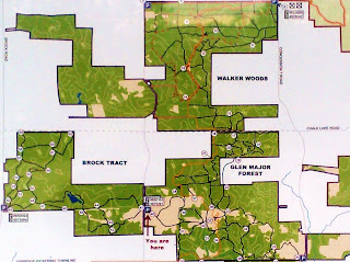
My buddy O'Malley and I got up early Saturday morning, strapped our bikes onto the back of my family's van and drove up to East Duffins Headwaters for a few solid hours of biking. This fairily well-kept secret of the GTA is a hiking and mountain biking park located in Glen Major forest. The park is owned by the Toronto Regional Conservation Authority (TRCA) and, although not fitted out with large berms, beams or MTB-specific structures, it is spectacular for its single track and quite a few good hills. Not to mention the *huge* length of its trails - there are enough winds, forks, and parallel paths that you wouldn't have seen them all in one full day of riding. Its on Sideline 4, a few kilometers north of Concession Road 9. Here a map of the place: Lots of multi-use, and MTB-oriented, trails. I fooled about with my phone and set it up so that GPS was on, and tracked the expedition: View MTBing the Glen in a larger map --> There are some more routes on...

Italian Trip in the Planning

Image
From early June this year, for two weeks, I'll be in Europe. Mostly Tuscany, to be more specific - since my dad and I are planning to do little father-son bike trip in Italy this summer. Italy isn't quite the most cycling friendly nation out there, I will admit (the Netherlands, Germany or France would be much better choices), but the Mediterranean climate, Roman ruins and picturesque scenes wherever one goes have swayed us.  That, and I kinda want to say "Hi!" to the pope. Pisa's Leaning Tower. I bet you a nickel this is the image that appeared in your brain when you read "Italy." As a veteran map-reader (from my boy-scouting days), I have been assigned the somewhat-daunting task of planning the cycling route, and all of our destinations. With a guidebook or two, and tips from friends, I've got the basic event agenda structured. But, what is really difficult however is the route forming; Italian roads are notoriously narrow (no shoulders!) and...

Bulldozers and the Bluffs

Image
Last post involved the path down at the base of the bluffs, and how it would make a great bike path (read the dedicated "Commuting, a Trail Proposal"  page). However, construction efforts have been stupendously slow.  Almost no actually progress has been made since two summers ago; dump trucks are only piling up the fill at the one end of the path. The red circle is where the current construction is ongoing.  Upon closer inspection of the site, a bulldozer and an excavator can be seen - these have served only to force the dumped loads into mounds. In the future (who knows how long), the rubble will be pushed into the water to construct the remaining section between Gates Gully and this path situated below the Guild Inn. The red line indicates the path being built now - about 240 meters. This is less than 1/17 of the amount of the path needed to be newly constructed (including breakwater trails), and has taken a full year to get only th...